


Where to hike in and around Corvallis this summer
Thinking outside the box this summer, literally!
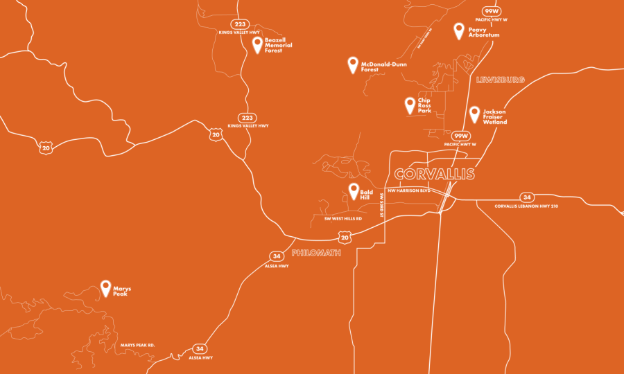
An illustrated map created on June 25 showcasing local trails on the north and west side of campus.
July 3, 2023
When classes have calmed and the temperatures rise, Beavers and Corvallis residents alike may need to think outside – no box required – to fill their days this summer. Here is a breakdown of some of the top spots in Corvallis to hike this summer.
West of campus
For those looking for a moderate to easy trail close to the heart of town, look no further than just west of campus where the Oregon State University to Bald Hill trail begins. The full trail is 3.6 miles and its half paved, half dirt path makes this more of a walk than an intense hike.
Bald Hill also offers a number of other hikes from the parking lot and trailhead off of Oak Creek Road.
- Bald Hill Natural Area Loop (3.6 miles). This provides a shorter but potentially more moderate level trail.
- Mulkey Ridge to Cardwell Hill Trail (12.6 miles out and back). This provides a full day out in the sun through Bald Hill farm and up to Cardwell Hill through the trail systems of Bald Hill natural area.
Dogs are welcome while leased on Bald Hill trails.
The Fitton Green Natural area – located near Bald Hill with a connecting path between the two – holds a number of trails as well offering similar views with a different path than the neighboring natural areas.
- Fitton Green Natural Area Trail (5 miles out and back). This trail can be a bit more challenging, with some elevation changes making this a more moderate level hike with a lookout over the natural area at the end.
- Allen Throop and Cardwell-Fitton Connection Loop (1.7 miles). This trail provides an easy walk and shorter time commitment than others in the area for those looking for some time in nature.
Dogs are welcome while leased on Fitton Green trails.
North of campus
Another area providing plenty of options for hikers’ choice in trails is the Chip Ross Natural Area, located near Timberhill Park and Timberhill Natural Area. Most hikes here provide more than a leisurely walk through the woods, with elevation changes and longer routes rated at a moderate level.
- Main Chip Ross Loop (1.5 miles)
- Main Chip Ross, Lower Dan and Road 612 Loop (3 miles)
Both of these trails provide a shorter loop option for those looking to explore the area on a time crunch, but still include the elevation changes of the area.
- Dan’s Trail (6.8 miles)
- Dimple Hill and Horse Trail Loop (7.5 miles)
These trails take hikers to viewpoints overlooking the natural area and parts of Corvallis. Along the way hikers will experience the lush forest, small bridges over water and wildflowers if caught at the right time.
Dogs are welcome while leased on Chip Ross trails.
Chip Ross also offers a trail (7.6 miles, Chip Ross Park to Dimple Hill Trail) leading to the edge of the McDonald and Dunn research forests, located a bit further north but only 20 minutes driving time away from campus.
The forest is frequently used by OSU’s forestry department, alongside providing recreation for residents.
Within the McDonald-Dunn forest are numerous trails for those of all levels and various including trails traveling up to Dimple Hill, Lewisburg Saddle and Vineyard Mountain.
Easy hikes:
- Nettleton and Vineyard Mountain Short Trail (0.7 miles)
- Ridge Trail to Sulphur Springs Loop Trail (3.5 miles)
- Jackson Fraiser Wetland Hike (0.9 miles). Although located across from McDonald-Dunn forest, this trail provides a leisurely stroll outside of downtown and campus for those looking to get away.
Moderate hikes:
- Calloway Intensive Loop Trail (3.2 miles). This trail offers views of both new and old growth, in addition to walking alongside a lake for portions of the trail.
- Tower Trail Loop (3 miles). This trail takes hikers up to a stone tower while also getting a view of the forest that provides little evidence that the city is just a short drive away.
- Peavy Arboretum 500 Road (3.7 miles). This is an out and back trail, traveling along old growth, a lake and new growth throughout the steady incline hike.
Hard hikes:
- Patterson Road 600 to Road 610 Loop (6.2 miles). While difficult level hikes are hard to come by within an hour of Corvallis, this short but difficult trail offers an option for those looking for an outdoor workout nearby.
- McCulloch Peak Loop (7.1 miles). Similar to the Patterson Road trail, this path provides more of a challenge, taking hikers up to views overlooking the valley and views of the college of forestry work within the forest.
- Forest Peak Trail (7.2 miles)
Dogs are welcome while leased on McDonald-Dunn trails and may be allowed off leash in some areas.
Options with a drive (45 minutes to one hour away)
For avid hikers, fifth year students and long time Corvallis residents, there are plenty of hiking options near Corvallis for a full or even half day trip getaway.
Mary’s Peak offers a number of trails starting from the parking lot to the summit or along the mountain giving high up views of the valley and city for miles around any end point.
- East ridge Trail (6.1 mile loop)
- Mary’s Peak from Summit Parking (1.4 miles)
Northeast of Corvallis is the famous Silver Falls State Park, offering waterfall views and moderate to hard level hikes for those willing to make the drive.
Just southwest of Corvallis is Alsea Falls Recreation Site. Here, hikers can expect four easy to moderate hikes traveling through the woods reaching waterfall views, making this a great choice to get away during those hotter days in town.
- Alesa Falls and Green Peak Falls (2.4 miles). Easy level out and back trail.
- Alesa Falls, Fall Creek, and Springboard (5.9 miles). Moderate level loop trail.
Towards Lebanon and Sweet Home, east of Corvallis by about an hour is the Green Peter Fire Lookout Trail. This trail provides another hard level option for those experienced hikers looking to get away with a 13.3 mile out and back trail.
All trail difficulty ratings provided by AllTrails.