


OSU leads in Unmanned Aircraft Vehicles research
January 8, 2018
Drone technology has potential in agriculture, forestry, oceanography.
A massive blue whale breaches, controlled and customized pesticide use, mapping diseased vegetation based on light refractions; these are only a few of the applications drone technology can perform.
Most commonly referred to as drones, unmanned aircraft vehicles or systems command much more than just air. UAS technology can, and is, applied to multiple mediums and disciplines throughout Oregon State University research labs.
OSU is a part of the Unmanned Aerial Systems Test Range Complex, meaning it is one of the few areas approved by the Federal Aviation Administration for UAS testing, according to the OSU research office webpage.
According to Mark Peters, the institutional compliance officer for UAS operations, drone research conducted at OSU spans a broad range.
“We’ve probably in the last two years have had over 500 missions or flights for research purposes,” Peters said. “We’ve had numerous others for marketing groups and for promotional videos.”
Peters’ job is to make sure faculty and staff have proper certification for UAS work, as well as to verify that any flight to be conducted follows FAA regulations, according to Peters.
“A lot of folks think of it as a toy or as a microscope in the sky and what it really needs to be thought of is if you’re going to be checking out a car from OSU motor pool,” Peters said. “We all have to follow the rules of the roads, we have to have a license and be safe.”
According to Peters, students can now receive FAA certification and training through OSU.
“We do certify a lot of students who happen to work with faculty on research projects,” Peters said. “We have around 40 students, mostly graduate students, who are certified to be pilots.”
Over 60 different drones have been registered and used through OSU, according to Peters. Each one contains its own unique set of sensors that record and store information.
Michael Wing, an associate professor of geomatics and director of the Aerial Information Systems, employs drone technology to create 3-D models of forests.
“There are a variety of sensors able to detect light and reflectance and sometimes heat from an object,” Wing said. “And we use that information gathered to determine something about the objects.”
According to Wing, OSU is near the forefront of UAS/UAV research.
“We have a long and distinguished history of remote sensing at OSU,” Wing said. “The trick here was to legally get sensors on unmanned aircraft and to fly them.”
UAS regulations considerably loosened in 2016, allowing for easier access and control, according to Wing. Previously, wait times for approval and data processing could take as long as six months.
Researchers can glean information from drone sensors using LIDAR technology, according to Wing.
“The acronym stands for Light Detection and Ranging, and what this is, it’s a sensor that sends infrared wavelengths and those go and strike an object. And we get a reflectance, meaning the infrared energy goes back towards the sensor,” Wing said. “And we expect the infrared energy to travel back at the speed of light. We measure the distance between the sensor and the objects on the ground and the time it takes the infrared energy to travel.”
This information in turn creates a 3-D model of the object in question and stores information such as temperature, location, composition and reflected light spectrum, according to Wing.
This technology is currently being implemented in the College of Agricultural Sciences, according to John Talbott, the assistant director of the Agriculture Experiment Station and director of the Western Sun Grant Regional Center.
Applications include monitoring riparian habitats, vegetation health and GPS allocation of harvests, according to Talbott.
“We look at drones not as just aerial devices. Folks up at the North Willamette Research Center have developed what we call a smart sprayer,” Talbott said. “It’s something that mounts on a tractor. And as you’re driving through your crops, the sprayer actually senses what’s going on with the plant as you’re driving the row.”
According to Talbott, smart sprayers are primarily used in orchards and for nursery crops.
“It selects the correct herbicide or pesticide to use, sprays it on the area affected rather than spraying the entire orchard or the entire nursery. It just does a little bit there’s no overspray,” Talbott said. “It reduces the use of herbicides and pesticides dramatically.”
Other UAS technology being employed at OSU takes a more non-intuitive approach, according to Talbott.
“We’ve worked with some drone developers more on ground-based drones. In other words, think of an ATV loaded with sensors that can run down through your orchard,” Talbott said. “The thing with orchards, if you think about cherries, pears and apples, you need something that looks up. That’s where the fruit is.”
Another endeavor being pursued is conducive for local grass farms, according to Talbott. Sensors mounted on grass seed combines measure how much seed is being harvested and georeferences it to the field it was harvested from.
“So when you’re done harvesting your seed, you can see, ‘OK, I got this much yield here, why is that? Was is fertilizer, was it soil moisture?’ Those kind of things,” Talbott said.
Considering the progression of UAS sensor technology, Talbott describes his dream UAS project, sensors can be used in other settings, according to Talbott.
“One of the things I’ve always wanted to do is develop a smart greenhouse. The idea would be you have this greenhouse that is essentially outfitted with every sensor that we can come up with,” Talbott said.
Talbott’s end goal is to be able to operate UAS’s that can map vegetation health based on this sensor information, as well as build a database of healthy local plants and their non-healthy counterparts.
“The image that you get out of that is going to have a unique signature between a healthy plant and an unhealthy plant,” Talbott said.
According to Wing, this is possible since distressed or diseased vines reflect a different infrared signature than healthy vines, something that can’t be distinguished by the human eye. This is also the case for other diseased plants besides grapevines. Wing uses a sensor called a multispectral sensor that reads the light spectrums that aren’t visible to human perception, but which are being reflected by objects.
“It means that we look at reflected light in a specific way,” Wing said. “We could really look at things like plant stress and agricultural health. Other places where there’s vegetation.”
Chris Parrish, an associate professor of geomatics in the School of Civil and Construction Engineering and the director of OregonView, works with UAS technology to survey and map coastal areas and assess bridge safety. Parrish and his lab work with the Oregon Department of Transportation and the Pacific Northwest Transport Consortium to improve bridge infrastructure and inspection using LIDAR and UAS technology.
“There is currently a lot of interest in UAS as a possible cost-saving and safety-enhancing tool for bridge inspection,” Parrish said in an email. “The idea is that a drone can be maneuvered alongside the bridge and its camera tilted and zoomed to obtain high-resolution imagery of a feature of interest, all while the inspector keeps both feet firmly on the ground.”
Conversely, in Newport, OSU professors such as Parrish use UAS technology to map and read local data. Parrish works with UAS’s to map local coastlines.
“One of the other main types of LIDAR that my students and I are working with is topographic-bathymetric LIDAR, which can map elevations both above and below the water surface,” Parrish said in an email.
Mapping the coast comes with its own set of challenges, according to Parrish.
“Many people assume that nearshore, coastal areas around the world have already been very well-mapped, but unfortunately, that’s not the case,” Parrish said in an email. “The area extending from the shoreline to approximately the 20-foot depth contour is actually one of the most challenging to map because you often have to contend with breaking waves, bubbles, foam and suspended sediment in the water.”
The specific measurement of depth known as bathymetry can help keep coastal populations safe and improve policy, according to Parrish.
“Other examples of how nearshore bathymetry is used include storm surge modeling, nautical charting and coastal change analysis,” Parrish said in an email. “With nearly half the world’s population living near the coast and sea levels rising, nearshore bathymetry is likely to become even more important in coming decades.”
Both undergraduate and graduate students work in Parrish’s lab using technology to map coral reef structures in the U.S. Virgin Islands and investigate taking shallow bathymetry measurements from atmospheric drones in coordination with the National Oceanic and Atmospheric Administration and the National Aeronautics and Space Administration.
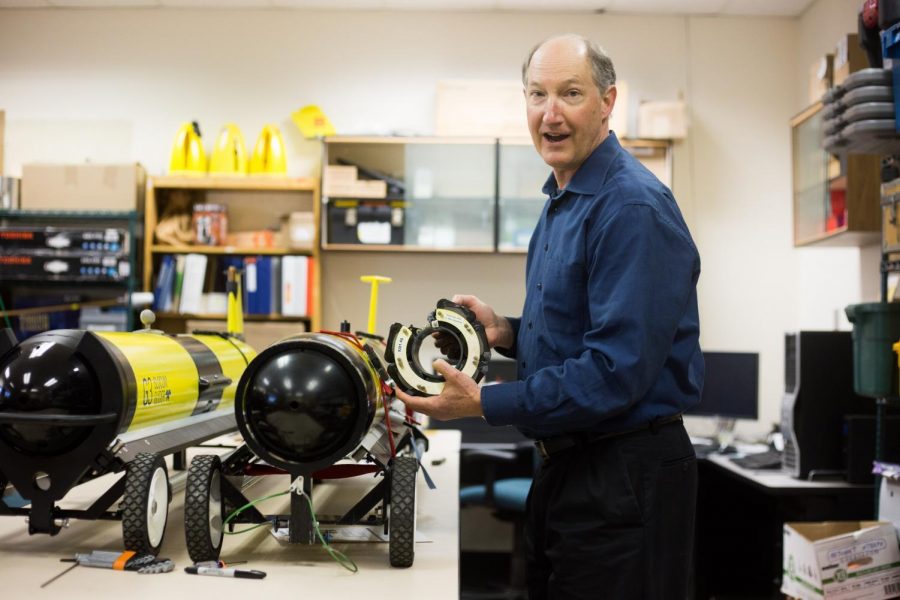
Researchers such as Jack Barth, executive director of the Marine Studies Initiative and professor at OSU, use UAS technology referred to as gliders to map and record data. Sensors record temperature, conductivity, depth, dissolved oxygen levels and chlorophyll fluorescence, according to Barth.
“So plankton, if you hit them with a certain wavelength of light, they’ll re-emit their own kind of light,” Barth said. “So we go through the ocean flashing light and light will flash back. Depending on the strength of the flashback is how much chlorophyll is there.”
According to Barth, chlorophyll fluorescence shows the overall concentration of phytoplankton in the sample. These readings show the overall status of the water being sampled.
“The reason it matters is because there is a healthy coastal marine ecosystem offshore,” Barth said. “And we like to say it all starts with the physics.”
Although skimming across water and temperature differences cause currents and swells, gliders stay on their route thanks to both GPS and cell phone satellite tracking, according to Barth. Gliders contain clever methods of shifting internal weights to control navigation and researchers check in every six hours to take readings year round.
“If they get confused or haven’t heard from us, say we miss the connection when it tries at six hours, it’ll keep doing its mission but if it doesn’t hear from us in a day, it’ll abort and send home a message that says, “Wake up you guys I’m lonely, come get me.”
According to Barth, this pathway of study has been pursued for the past 40 years or so by OSU researchers. Barth and his team have collected massive amounts of data using glider technology for the past 12 years.
“It’s so much, it’s kind of in that realm of big data now,” Barth said, “One of the main things we’re working on is with long term changes. We’re looking at temperature structure and dissolved oxygen.”
The overall product is raw data that researchers can use to extrapolate patterns and hypotheses about the changing coast, according to Barth.
According to Talbott, spanning from inland vineyards and orchards to open ocean currents, UAS technology has become ubiquitous.
According to Peters, a possible future could involve artificial intelligence and UAS technology.
“Another piece is that in terms of student activity the thing that isn’t talked about is really the cool piece,” Peters said. “What students are being involved in are drones that don’t need pilots. They’re working on artificial intelligence to tell drones to operate.”